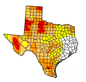
The latest NOAA drought outlook shows possible improvement for a larger part of the state than in the past forecast.
More of Texas could begin to recover from the drought in the coming months, but it may not be soon enough to save many of the state’s crops.
The three-month outlook from the National Oceanic and Atmospheric Administration (NOAA) Climate Prediction Center, released Thursday, shows a larger portion of the state possibly improving than in a previous forecast, with much of East Texas listed as “likely to improve” or having “some improvement,” however the drought is forecast to “persist or intensify” in the Western half of the state.
Though the US Drought Monitor Map released Thursday shows no difference in how much of the state is experiencing drought this week, it does show less of Texas under the two most severe drought stages. Much of this exceptional drought is in deep South Texas, where it is taking a toll on crops. Continue Reading →
Generations of Plainview residents worked at the plant. Aubrey Rivera, Aliva’s daughter, told her her mom she wanted to work there when she grew up.
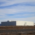
Criselda Avila lost her job at the Cargill Beef Processing Plant in Plainview. Now she’s unsure what she’ll do and what will happen to the Southern Plains town she calls home.
Jose Amaya and his wife Zuzema have relatives who have already moved away.
Images of cows can be found on the street signs of downtown Plainview
Ruben and Riene Olivas worry what will happen to their business now that the plant has closed.
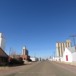
The streets of Plainview.
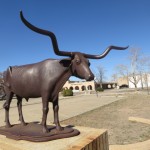
Statues of cattle can be found throughout town. A nod to the local importance of the industry.
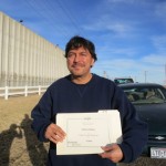
Johnny Ray Muniz leaves his last shift at the Cargill Beef Processing Plant.
As Mayor Wendell Dunlap plans for the city’s recovery, “your prayers are appreciated,” he said.
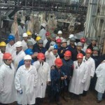
A group picture taken the day the last cow came through the Cargill Plant.
The Cargill Excel Beef Processing plant in Plainview, Texas.
Irene and Ruben Olivas say the ripple effect of the plant closure threatens the bakery where they work.
By the time the cows arrived at Criselda Avila’s work station at the Cargill Excel Beef Processing Plant in Plainview, they had already been slaughtered, skinned and gutted. The carcasses came in hanging from a long chain that ran over the plant floor. They were divided up and divided again. Avila worked on skirt steaks.
“You gotta spread it open and then cut the little skirt off, and then throw that on the table and then peeling and just trimming the fat off is what it was,” she remembered recently, sitting in her living room. “You know, fajitas.”
It was numbingly repetitive work. More than 4,500 cows went through the plant every day. So when Avila was done with one, there was always another behind it. Then, on the last day of January, she saw something she never expected to see.
Photo courtesy of Criselda Avila
A group picture taken the day the last cow came through the Cargill Plant.
“There were the last few cows, then the last cow was coming down the chain, and people there were just banging our hooks,” she said. “People started crying, like ‘oh my god this is the end of it.’”
That was how the city of Plainview lost over 2,000 jobs. After years of drought, the U.S. cattle herd is at its lowest level since 1952. Cargill Meat Solutions, the company that owns the plant, says there are simply not enough cows in existence to keep the plant running. For years ranchers across Texas have been cutting back their herds in response to the historically dry weather, but this is the first time those cuts have reached up the supply chain, to hit the industrial heart of a Texas city. The plant closure could have wide sweeping ramifications across the region. Continue Reading →
Lavaca Bay in Calhoun County is one proposed site for an LNG Terminal.
If you think the price of natural gas is too low and think the solution is to increase demand by exporting the stuff, who will benefit? Continue Reading →
A Black Bear spotted in Brewster County. Black bears in Texas are generally smaller than in other parts of the country.
There are hardly any bears in Texas, but it hasn’t always been that way. Black bears used to roam the state from the Piney Woods of the east to the mountain ranges of the far west.
Then American colonists arrived.
Bear hunting was “part of the hunting culture that early Texans enjoyed,” Texas Parks and Wildlife Diversity Biologist Jonah Evens told StateImpact Texas. “Eventually we wiped them out completely from the state.”
By the early 1900s there were no bears left. The nearest breeding populations remained across the border in Mexico.
“And then there were no bears in Texas for decades until they returned to Big Bend National Park, I believe it was the early 80s,” Evans said.
That Big Bend population in remained stable, but never expanded to other areas. In East Texas the occasional bear would wander in from Louisiana, but never stuck around to have bear babies. And that’s how things stood until just a couple of years ago.
When San Francisco Bay area landscape photographer Thomas Bachand first heard about the Keystone XL pipeline, which will take heavy oil harvested from tar pits in Canada to refineries in Texas; he started looking around for a map of it. And he quickly discovered there wasn’t one to be found.
“Obfuscation is a big part of this [pipeline] project,” Bachand tells StateImpact Texas. To show where the pipeline will go — how many rivers, wetlands and streams it will cross, for instance — Bachand started the Keystone Mapping Project. Painstakingly collecting what information he could get from public agencies, he was able to put together an interactive map of the pipeline, which you can view above.
We recently spoke by phone with Bachand to learn about how he put the map together.
Q: So how’d you get involved in this?
A: I started out wanting to scout the route for a potential photography project. So I went looking for a map, and discovered there wasn’t one. I went over to the State Department website, and found some great information, but then I discovered there wasn’t any route information. So while you could find where a wetland was, for example, it would say, ‘Wetland 500 feet from Mile Post 182.’ You couldn’t find where Mile Post 182 was. The State Department was helpful, but they weren’t allowed to release the information. So I started looking around, and I went to the states. One gave me the mile post information, but everyone else either didn’t have the information, or they wouldn’t release it.
From January to September the U.S. had the warmest first nine months of the year in its history, according to the latest ‘State of the Climate‘ report from the National Oceanic and Atmospheric Administration (NOAA). And there have been numerous other anomalies in the climate as of late, the report says.
“The average combined global land and ocean surface temperature for September 2012 tied with 2005 as the warmest September on record, at 0.67°C (1.21°F) above the 20th century average of 15.6°C (60.1°F),” the report says. The records go back to 1880.
There are some other happenings in the earth’s climate that may interest you, like the fact that Japan saw record warmth, while the U.K was cooler than normal. You can read about them all over at the NOAA.
With the Texas drought, we experience swings: one week the drought monitor map looks good. Another it looks bad. This week, file it under the “good column.”
In case you missed it, Texas got some rain recently. All of Texas. “Practically the entire state got at least one inch of rain during the last week of September to Oct. 1,” the Texas A&M Agrilife Extension says in their latest crop and weather report, “with many regions getting as much as nine inches, according to the National Weather Service.”
And the results show. The latest US drought monitor map has only three percent of the state in the worst stage of drought, with nearly seventeen percent of Texas completely drought-free. A year ago this week, over 86 percent of the state was in the worst stage of drought. Continue Reading →
Last week, the Environmental Protection Agency (EPA) named twelve new National Superfund sites in the country, with two of them in our very own Lone Star State. Superfund sites are polluted locations designated by the EPA as hazardous. The designation allows for the federal government to overhaul clean-up of the toxic sites and find parties financially liable for the contamination.
A Pasadena watershed and a well water site outside Forth Worth were both added to the “National Priorities” list, a distinction the EPA makes to say they intend to investigate the site even further. Just five percent of sites initially investigated by the EPA are added to the National Priorities List. Texas is home to 50 of the 1,315 National Priority sites. So where are these sites, and what happened there? Let’s take a look.
At least forty people have died from the West Nile virus in Texas. The neuroinvasive strain of the virus has been confirmed in nearly 500 cases in the state, more than any other year before. Naturally this brings up a lot of questions: Is it always fatal? Where in Texas is it a problem? How did it get here in the first place?
Where West Nile Has Hit Texas
Let’s start with where West Nile is in the state. As you can see in the map to the right by Texas Tribune, the virus is mostly in North and Central Texas. (Click here for an interactive version.) But new numbers reported by KUT News today show that the problem is becoming worse in Central Texas — mostly the area around Austin — while it’s improving in Dallas County, which has likely already hit its peak number of cases.
The US Drought Monitor Map of July 19 shows marked success for Central and East Texas after just one week of strong rains.
Extra! Extra! It’s the Drought Monitor Map we’ve been waiting for – the one that tallies last week’s plentiful rains. As expected, much progress was made. Perhaps the most notable change on the map: almost all of Southeast Texas is in the white, meaning completely drought-free and likely to stay that way.
In addition, the rains were so strong in Central Texas that parts of the area moved down a whole drought stage in just one week. Travis County, which contains Austin, moved from Stage 2 of the drought to mostly Stage 1. (There is still a small sliver in the northwestern part of the county in Stage 2.) Williamson County, directly north of Travis County, moved from mostly Stage 3 to mostly Stage 2. Several counties west of San Antonio moved from Stage 2 to Stage 1 in just one week as well.
As Texas gradually pries itself out of drought, much of the rest of the country delves deeper into it. According to the National Climactic Data Center, 56 percent of the US is now facing drought conditions. This is significant because it is the largest percentage of area since the infamous drought period of the 1950s. Since much of this is taking place in America’s Corn Belt, officials are concerned about the increase in the price of grain, especially corn.
Back in Texas, progress was real and rapid last week, but do residents of the state no longer need worry about the drought? The consensus amongst some of the state’s meteorologists: the rainfall was great, but it’s gonna take a lot more than a week’s worth of rain to get out of a two-year long record drought. Continue Reading →
About StateImpact
StateImpact seeks to inform and engage local communities with broadcast and online news focused on how state government decisions affect your lives. Learn More »