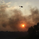
Why Wildfires are Growing, and Whether You’re at Risk
All this week we’re bringing you stories on the 2011 Labor Day Wildfires that destroyed over a thousand homes in Central Texas. On Monday, we looked at some of the complications that led to the fire beyond the well-known heat and drought. Later today, we’ll bring you a story of a narrow escape from the Pedernales Bend Fire that weekend.

Map by NPR
A new map by NPR shows you the fire risk in your area, and where major fires are currently burning in the country.
One takeaway from the series is that wildfires are becoming larger and more destructive. In the slideshow report above by NPR science correspondent Christopher Joyce, you can learn why the danger has grown.
What’s the current fire risk in your area? Well, there’s a map for that. Matt Stiles and the NPR digital team have put together an interactive map of wildfire dangers and active fires in the country, which you can see here. It’s updated daily. For the moment, Texas falls in the low and moderate risk categories.