Why Earthquakes Are Shaking North Texas: Scientists Investigate Links to Disposal Wells
StateImpact Texas
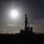
A hydraulic fracking operation in the Barnett Shale.
Update, November 2013: Quakes have now struck in a different area outside of Fort Worth near the town of Azle and Eagle Mountain Lake. You can read about that series of quakes (and see them mapped) here.
Yet another earthquake has rattled North Texas. Early Tuesday morning, the city of Keene, 25 miles south of Fort Worth, experienced what the U.S. Geological Survey says was a 2.4 magnitude earthquake.
Earthquake events have been on the rise in an area that hasn’t really seen a whole lot of quakes in the past. That was before disposal wells were constructed nearby, used to dispose of wastewater from hydraulic fracturing, or “fracking.” (For an in-depth look at disposal wells, check out this report from ProPublica.)
“We’ve been looking at the question of whether the number of earthquakes occurring across the mid-continent has changed in recent years. And we find that there is a statistically significant increase in the rate just over the past several years. And many of these are in areas where we know there is a lot of energy activity,” U.S. Geological Survey geophysicist Bill Ellsworth tells StateImpact Texas.
(Update: Read about the Dec. 12 quake outside of Fort Worth here.)
In less than a month, the Johnson County area has been shaken by at least seven different quake events.
Related
Posts


Blogger Sharon Wilson, an opponent of fracking, chronicled the tremors recently on her site. All of the data comes from the US Geological Survey, which we double-checked. Each link will take you to the Survey’s event page for the quake:
- June 15: 3.2 magnitude quake in Burleson
- June 23: 2.1 magnitude quake nearby
- June 24: 3.5 magnitude quake in Keene
- June 26: 2.6 magnitude quake in Alverado
- June 29: 2.3 magnitude quake in Keene
- July 6: 2.7 magnitude quake in Keene
And if you compare the location of disposal wells and earthquake events in Johnson County, you’ll find an interesting pattern. The two maps appear to match up. Here’s a map of disposal wells in the area*:

Map by Southern Methodist Univeristy
Disposal and fracking wells in the Dallas-Fort Worth area, as of March 2010. Disposal wells are in green.
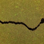
And here’s a map of the recent quakes in the area, all in Johnson county:

MAP COURTESY OF EARTHQUAKETRACK.COM
A map showing the recent outbreak of earthquakes in North Texas.
Ellsworth claims that the experience in North Texas parallels that of a California geothermal field called The Geysers, just north of San Francisco. An explosion of industrial activity there has been responsible for more than a thousand earthquake events every year. Most of the quakes haven’t surpassed a 2.0 magnitude. Generally, an earthquake magnitude of 4.0 or larger is considered to be destructive. But Ellsworth says that “there’s always the possibility that something larger might occur.”
Similar clusters of earthquakes near injection well sites have been reported in central Arkansas, Oklahoma, and along the New Mexico-Colorado border.
But unlike naturally earthquake-prone sites like California, states like Texas might not be ready for the bigger quakes.
“In California or on the West Coast, we have very high building standards for earthquake safety. As we move away from the active tectonic margins, those building code standards are relaxed because there’s less of a threat. So, buildings in many parts of the central part of the country will be more vulnerable to the same earthquake compared to if that earthquake were to happen in an area such as California, Nevada, or Washington,” says Ellsworth.
While scientists and public officials alike work to study the link between disposal wells and induced earthquakes, citizens can and should take steps to prepare themselves, says Ellsworth.
The U.S. Geological Survey recommends a 7-step plan to manage risk and respond to an earthquake event. You can learn more about this by reading the USGS guide to earthquakes, Putting Down Roots in Earthquake Country.
Further Reading: More on the Science Linking Fracking Disposal Wells to Earthquakes
Sheyda Aboii is an intern with StateImpact Texas.
*An earlier version of this post used a map of fracking wells in the area to show where they are in relation to earthquakes. The post has been updated to show a map of both fracking and disposal wells in the area as of 2010, according to a study from Southern Methodist University.