Terrence Henry reports on energy and the environment for StateImpact Texas. His radio, print and television work has appeared in the New York Times, The Washington Post, The Atlantic, NPR, The Texas Tribune, The History Channel and other outlets.
He has previously worked at The Washington Post and The Atlantic. He earned a Bachelor’s Degree in International Relations from Brigham Young University.
Some of these potential policies have big implications for the massive energy industry (and aging coal power plants) in Texas, but at this point it’s really anyone’s guess how exactly it will all play out. Continue Reading →
Republican chairman Barry Smitherman easily won re-election to the state agency that oversees oil and gas drilling. Smitherman faced no Democratic opponent.
In the race for the open seat, Republican attorney Christi Craddick defeated Democratic candidate Dale Henry.
Both candidates received significant funding from the oil and gas industry.
The races are largely a forgone conclusion, but thanks to our friends at the Texas Tribune, we’ll be carrying live election results for the two races for the Railroad Commission of Texas (which oversees oil and gas drilling in the state) tonight.
Running for re-election is chairman Barry Smitherman, who faces an easy road back to the commission as no Democratic candidate is opposing him (though there are Libertarian and Green Party candidates in both races). For the open seat, Republican attorney Christi Craddick is widely expected to defeat Democratic candidate Dale Henry. As the results come in, the widget above will display them. And you can listen to live election coverage on KUT 90.5 FM in Austin and KUHF 88.7 FM in Houston.
When San Francisco Bay area landscape photographer Thomas Bachand first heard about the Keystone XL pipeline, which will take heavy oil harvested from tar pits in Canada to refineries in Texas; he started looking around for a map of it. And he quickly discovered there wasn’t one to be found.
“Obfuscation is a big part of this [pipeline] project,” Bachand tells StateImpact Texas. To show where the pipeline will go — how many rivers, wetlands and streams it will cross, for instance — Bachand started the Keystone Mapping Project. Painstakingly collecting what information he could get from public agencies, he was able to put together an interactive map of the pipeline, which you can view above.
We recently spoke by phone with Bachand to learn about how he put the map together.
Q: So how’d you get involved in this?
A: I started out wanting to scout the route for a potential photography project. So I went looking for a map, and discovered there wasn’t one. I went over to the State Department website, and found some great information, but then I discovered there wasn’t any route information. So while you could find where a wetland was, for example, it would say, ‘Wetland 500 feet from Mile Post 182.’ You couldn’t find where Mile Post 182 was. The State Department was helpful, but they weren’t allowed to release the information. So I started looking around, and I went to the states. One gave me the mile post information, but everyone else either didn’t have the information, or they wouldn’t release it.
Just a few weeks ago, staff had recommended that the agency not seek an emergency drought plan, which has stricter cutoffs for determining whether water is sent downstream for irrigation.
“Since then, conditions have not measurably improved, and updated weather forecasts call for drier conditions,” the LCRA says in a statement late Friday afternoon. Now staff will recommend that the board of the LCRA adopt an emergency plan, albeit a “different” one from what they have currently. The agency declined to offer specifics as to how it’s different in their statement, saying only that details will be available at a meeting in a few weeks.
New forecasts say there's lower odds of a wet, cool winter for Texas.
Texas really needs a wet winter. And until recently, the forecasts called for exactly that: an El Niño weather pattern in the Pacific was scheduled to appear, which typically results in cooler, wetter winters for the state. Now it looks like El Niño’s changed his mind, and the implications for an already-parched state are huge.
“El Nino would have given us our best shot at above-normal rainfall during the winter,” John Nielsen-Gammon, the state climatologist, says. “With much of the state having had two years-plus of drought, a nice wet winter would have been helpful in breaking it.”
But the forecasts aren’t always predictive of what will actually happen. Last winter, under La Niña conditions (which largely caused the drought of 2011 that still continues today), the state actually received above-average rainfall. Just not enough to bust the drought. Continue Reading →
In what will be welcome news to environmental groups, on Tuesday the Texas grid gave the green light to Luminant to idle two units at their Monticello coal power plant and lignite mine in Northeast Texas for the winter.
Photo by SAUL LOEB/AFP/Getty Images
Smoke stacks at American Electric Power's (AEP) Mountaineer coal power plant in New Haven, West Virginia, October 30, 2009.
Earlier this fall, the Electric Reliability Council of Texas (ERCOT), which runs the grid, announced they would review Luminant’s request to idle the units from December until June. Luminant wants to mothball them over the winter because they say they aren’t making enough money to keep them running.
The company had threatened to shut the same coal units down last year because of an impending Environmental Protection Agency rule. When that rule was remanded, Luminant said they would mothball the units — which are nearly forty years old — for half the year because they aren’t profitable.
“With power prices very low, those two units are not economical to run during these low demand seasons,” Allan Koenig, vice president of communications for Energy Future Holdings, the parent company for Luminant, told us earlier this month. Energy Future Holdings is currently in a financial bind — a recent Bloomberg News analysis declared the company “technically insolvent.” The last seven quarters have seen consecutive losses for the company. Continue Reading →
A man pushes a woman and a dog in a boat a boat after their neighborhood experienced flooding due to Hurricane Sandy, on October 30, 2012, in Little Ferry, New Jersey.
“We can never say one specific event is because of climate change, but what we can say is that climate change has altered the background conditions over which these events occur,” Hayhoe tells us. A hurricane at this time of year, for instance, isn’t highly unusual. She says it happens about once every ten years.
“But what is unusual about Sandy is the size, the strength, and the pathway or trajectory it followed,” Hayhoe says. The first, and most obvious, climate change factor that exacerbated Sandy was a rise in sea levels:
Sea Level Rise: Hayhoe says that on average, sea levels have gone up about seven inches in the last hundred years in the U.S. because of climate change. “So when any hurricane occurs, you now have an extra seven inches of height on the storm surges,” Hayhoe says. That can flood an otherwise safe street, or topple a sea wall or levee that would normally hold. Continue Reading →
A young boy runs along Rockaway Beach as Hurricane Sandy begins to affect the area on October 29, 2012 in the Queens borough of New York City.
In this handout image supplied by the US Coast Guard, The HMS Bounty, a 180-foot sailboat, is submerged in the Atlantic Ocean during Hurricane Sandy approximately 90 miles southeast of Hatteras, North Carolina, on October 29, 2012. Of the 16-person crew, the Coast Guard rescued 14, recovered a woman who was later pronounced dead and are searching for the captain. The HMS Bounty was built for the 1962 film Mutiny On The Bounty and was also used in Pirates Of The Caribbean.
A couple walks in the rain as a darkened Manhattan is viewed after much of the city lost electricity due to the affects of Hurricane Sandy on October 30, 2012 in New York, United States.
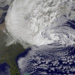
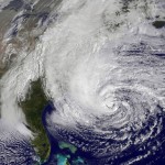
In this handout GOES satellite image provided by NASA, Hurricane Sandy, pictured at 1240 UTC, churns off the east coast on October 29, 2012 in the Atlantic Ocean.
The Empire State Building towers in the background of an apartment buliding in Chelsea, New York City, with the facade broken off October 30, 2012 the morning after Hurricane Sandy.
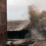
Waves break next to an apartment building which flooded from Hurricane Sandy on October 30, 2012 in Atlantic City, New Jersey.
Water floods the Plaza Shops in the wake of Hurricane Sandy, on October 30, 2012 in Manhattan, New York.
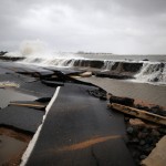
Heavy surf caused by Hurricane Sandy buckles Ocean Ave on October 30, 2012 in Avalon, New Jersey.
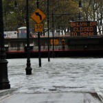
A flooded Brooklyn Battery park Tunnel October 30, 2012 as New Yorkers clean up the morning after Hurricane Sandy’s landfall.
Rising water, caused by Hurricane Sandy, rushes into a subterranian parking garage on October 29, 2012, in the Financial District of New York, United States.
Ocean Avenue is flooded caused by Hurricane Sandy, on October 29, 2012 in Cape May, The New Jersey coastline is feeling the full force of Sandy’s heavy winds and record floodwaters.
A photographer shoots waves generated from the remnants Hurricane Sandy as they crash into the shoreline of Lake Michigan on October 30, 2012 in Chicago, Illinois. Waves up to 25 feet high generated by winds up to 50 miles-per-hour were expected on the lake.
A newspaper cabinet is washed up on Ocean Ave., on October 30, 2012 in Cape May, New Jersey.
Some six million people were without power this morning because of Hurricane Sandy, and at least 33 are dead, many of them killed by falling trees. Travel and transportation has largely come to a standstill in many areas of the Northeast. In the photos above, you can see the impact of one of the most destructive storms in the area’s history.
And while the storm’s physical damage is limited to the East, that doesn’t mean it hasn’t been felt here in Texas. Many flights have been canceled at Texas airports. And several Texas utilities are sending staff East to help restore power in areas affected by Sandy.
Some thirty tree-trimming and eight distribution contractors from Austin Energy are headed Northeast to help, as are crews from Entergy, Oncor, and CenterPoint. AEP Texas is sending 81 employees to West Virginia to help AEP crews there restore power, and has released an additional 38 contact crews to help as well. And San Antonio’s CPS energy has a convoy of some 50 workers headed out to assist in restoring power in the Northeast.
People stand on the beach watching the heavy surf caused by the approaching Hurricane Sandy, on October 28, 2012 in Cape May, New Jersey. Hurricane Sandy is expected to hit the New Jersey coastline sometime on Monday bringing heavy winds and floodwaters.
A sign on dispay in Grand Central Station in New York October 28, 2012 as the MTA has been began an orderly shutdown of commuter rail and subway service in preparation for Hurricane Sandy .
In this handout GOES satellite image provided by NASA, Hurricane Sandy, pictured at 1410 UTC, churns off the east coast on October 28, 2012 in the Atlantic Ocean.
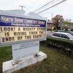
The North Shore Community Church displays a sign alluding to Hurricane Sandy on October 28, 2012 in Oyster Bay, New York.
A man walks on the boardwalk ahead of Hurricane Sandy on October 28, 2012 in Atlantic City, New Jersey. Governor Chris Christie?s emergency declaration is shutting down the city?s casinos and 30,000 residents are being told to evacuate. (
A boarded-up store remains open for business as the first signs of Hurricane Sandy approach on October 28, 2012 in Fairfield, Connecticut. The storm, which could affect tens of millions of people in the eastern third of the U.S., is expected to bring days of rain, high winds and possibly heavy snow in parts of Ohio and West Virginia.
nly a few bread items remain on the shelves at the Waldbaums grocery store as Hurricane Sandy approaches on October 28, 2012 in Long Beach, New York.
A man carrys a case of water down Lexington Avenue in midtown in New York October 28, 2012 as stores begin to close down in preparation for Hurricane Sandy .
A loader makes a sand barrier on the beach to help stop storm surge from approaching hurricane Sandy, on October 28, 2012 in Cape May, New Jersey. Hurricane Sandy is expected to hit the New Jersey coastline sometime on Monday bringing heavy winds and floodwaters.
A sign reads “Danger Ocean Closed” at the entrance to the beach, due to approaching Hurricane Sandy, on October 28, 2012 in Ocean City, New Jersey.
As Hurricane Sandy cuts a path of destruction through the eastern states, many are wondering about the science behind this ‘Frankenstorm’ and whether it has any clear connection to global climate change.
“There is a hierarchy of weather events which scientists feel they understand well enough for establishing climate change links,” Frank writes. “Global temperature rises and extreme heat rank high on that list, but Hurricanes rank low.” That being said, Frank write that warmer ocean temperatures do lead to more evaporation, “and that likely leads to storms with more and more dangerous rainfall of the kind we saw with Hurricane Irene last year.”
In situations like Sandy, climate scientists will often use an analogy: climate change is like putting expected extreme weather events on steroids. These scientists say that while it’s difficult to immediately attribute specific events to climate change (though not impossible, according to Frank), it is possible to say that many of these events are made worse by it.
StateImpact seeks to inform and engage local communities with broadcast and online news focused on how state government decisions affect your lives. Learn More »