Drought-Free and Lovin’ It? Not Quite Yet…

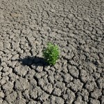
Photo courtesy of Lunchbox Photography via Flikr's Creative Commons. http://www.flickr.com/photos/jcorduroy/6817020034/
Even Thor's lightening, thunder and rain didn't free Central Texas fully from drought.
The word Thursday derives from the Old Norse thorsdagr, meaning “Thor’s Day.”
But here at StateImpact Texas, Thursday means something else entirely. It’s the day the U.S. drought monitor releases it’s weekly drought map!
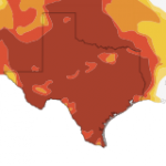
Thor was the Norse god of thunder, and parts of Texas saw plenty of storms (and rain) last week, raising hopes that the central part of the state would finally be able to proclaim itself drought free. Unfortunately, those hopes were dashed by the new map which shows the western edges of the Hill Country are still in moderate or severe drought.
But the map still holds good news for much of the state. The drought conditions continue to weaken, with the eastern part of Texas either seeing a normal amount of precipitation or listed only as “abnormally dry.” Even the Trans-Pecos region of far West Texas saw some improvement, moving from “exceptional” drought to “extreme” drought.
Exceptional drought still exists, however, in parts of the Texas Panhandle.
While the positive trend continues, reservoir levels remain low across the state even in areas that have seen rain. San Antonio expects water levels in the Edwards Aquifer, its chief source of water, could continue to drop despite the rains. The LCRA listed the Highland Lake System, an important water source for Austin and communities downriver, as only 51 percent full today.
“In order to fill Lake Travis, it’s going to take a really significant storm system, or series of storms,” Bob Rose, meteorologist for the LCRA told StateImpact Texas last week.
The situation out West is even more dire. Residents are hoping a summer monsoon season may bring relief in that part of the state.
Ironically, the rains have brought their own troubles to Texas. Flash flood warnings were declared in many counties earlier this week. Residents of Bastrop, Texas, where wildfires burned around 34,000 acres last year, now fear heavy rains may bring serious erosion to their county,


