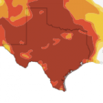
By the Numbers: Texas’ Long Heat Wave

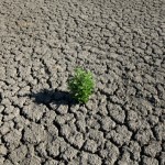
Photo by Mose Buchele
In Austin, a work of guerrilla art predicted the gradual desertification of Texas at the height of the 2011 drought.
On Tuesday, we reported on how multiple years of unusually warm weather in Texas has changed attitudes about what’s hot and what’s not.
In a nutshell: people are starting to think of hotter-than-average weather as the new normal here in Texas. This year is a case-in-point: thanks to a warmer-than-usual winter, 2012 is currently on track to be the 4th hottest year (in terms of average temperatures) in Texas. But many people, shell-shocked from last year’s record breaking heat, are thinking of this year as a welcome respite.
A lot of the warming trend has to do with weather patterns that take decades to run their course. Strong and re-occurring La Nina patterns in the Pacific, for example, are in large part responsible for the dry, warm weather that Texas has seen since 2005 (with the exception of two wetter-than-average years). And, as we’ve explained in the past, dry weather in Texas means warm weather. But scientists say global climate change has exacerbated those trends, creating even hotter hot spells and drier dry spells.
What does that mean for people who live in Texas? The last seven years have been pretty unbearable temperature-wise. In Houston, this year was on track to be become the warmest year on record (even warmer than last year) until recent colder temperatures broke the trend, says the Houston Chronicle’s Sci Guy.
Houston had one of its warmest winters and early springs, and the warmer than normal temperatures continued through the summer, although not nearly so warm as the city experienced in 2011. At that point the city was on pace to record its warmest year in 2012.
But according to new data from Charles Roeseler at the National Weather Service, this year’s average temperature through Oct. 31 now ranks third. Here’s the top five:
1. 74.5 degrees (1962, 2011)
3. 74.4 degrees (2012)
4. 74.0 degrees (1911)
5. 73.8 degrees (1963, 1927)
As the Sci Guy points out, not all of the above-average warmth this year is the product of dramatically extreme heat. It was the warm winter that brought Houston to the brink of breaking the record, something that Houstonians may have noticed, but likely wasn’t suffered through in the same way as, say, the summer of 2011.
But that’s not to say this year has not brought extremes either. Take the example of Austin.
Here’s a stat that would shock anyone who moved to Austin in 2007: The average annual number of triple-digit days in Austin is just thirteen. Why would that be shocking? Because every year for the past five years, Austin has seen more triple-digit days than average. In most cases many more:

Mose Buchele
Information provided by the National Weather Service.
And, as we reported on Tuesday, this trend could continue. In fact, the state climatologist says the drought, with its inherent hotter temperatures, could last up to another eight years.