This Week in Drought: The Two Sides of Texas

US Drought Monitor Map
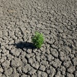
Drought is forecast to continue in hard-hit areas of the state.
The rain in South Texas has been fickle this spring. “Oh, we’ve had some rain,” says Ed Walker, Manager of the Wintergarden Groundwater Conservation District. “But it’s been an inch here, a half-inch there. It’s really dry.”
Walker’s work involves managing the underground water in the counties of Dimmit, La Salle and Zavala, a part of the state in the worst stages of drought, according to the latest U.S. Drought Monitor Map out today.
Ranchers are finding they need to lower the pumps in their livestock and irrigation wells, Walker says, as water tables drop. But “the lower the pumps get, the more it costs to pump [water]. And the deeper the pumps are, the less they work.”
According to a new federal forecast out today, over the next three months the drought is likely to continue in Walker’s region, and develop in other parts of South and West Texas. The eastern half of the state, however, is predicted to improve, and cease completely in some regions:

Map by NOAA
That roughly mirrors forecasts from the state grid’s meteorologist: the drought is likely to be worst this summer in the border regions of South Texas and the Panhandle.
“We’ve been pretty dry for the last 4 years,” Walker says. “We’re all still pumping [out water] and not putting anything back in.”