Measuring the Drought: How New Tools Show Its Impact

Photo courtesy of UT
David Maidment says new data tools can help us better prepare for drought
Tracking the changes in water availability across the state using a variety of tools is an integral component of predicting and responding to drought. That’s what David R. Maidment of the Center of Research in Water Resources at UT had to say at the Texas Water Summit held Monday. As a member of the innovative Drought Technology Steering Committee at UT, Maidment presented a set of data that showed the impact of the drought.
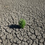
Let’s just say that the picture Maidment’s painted wasn’t comforting. “It’s possible to quantify a very important impact of the drought on our state – the loss of vegetation,” said Maidment. A satellite image of the state taken before the drought revealed a lush green landscape. Seconds later, the newest satellite image of Texas was revealed – bone dry, yellowed, accented with the thin, wispy trails of remaining vegetation.
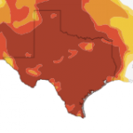
Researchers have increasingly turned to satellite imaging to gain a better handle on the situation. GRACE satellites, which measure the alterations in the force of gravity relative to water volume fluctuations, have indicated that over 100 cubic kilometers of water statewide was lost due to the 2011 drought. This figure amounts to the disappearance of approximately seventy Lake Travis’. Shallow groundwater reserves faired no better – over nine cubic kilometers were lost.
According to the Texas Soil Wetness Index, a tool monitoring the state’s soil water system, approximately fifteen cubic kilometers of water evaporated from the soil. Texas has seventy-eight cubic kilometers of water storage capacity to offer in the first meter of its top soil. “We can start to track the movement of water in the soils across the state,” claimed Maidment, a critical insight that may help regional leaders predict, plan for, and recover from drought.
Recent rainfall has offset some of the damage done, but the picture doesn’t seem to be any rosier out in West Texas. Unlike the drought experience in central Texas, the drought of West Texas is a chronic one, Maidment said. Many lakes in the area have gone completely dry. Currently, over 500,000 people remain dependent on Lake O.H. Ivie. But only about eighteen months of water supplies remain in the lake, which lost over 80,00 acre-feet of water in 2011.
This reality has motivated Maidment and fellow academics to call for the creation of a statewide water and climate model. An integrated system of data collected across Texas may better inform models providing the 6-18 month window necessary for “rational water decision making,” he said. Development of real time water models might better prepare the state for future climate fluctuations, he said.
You can see for yourself the progression and impact of the drought at our interactive web page, Dried Out: Confronting the Texas Drought.