Dr. John Nielsen-Gammon, Texas State Climatologist
Climate change has entered the discussion on water availability once again. “The same amount of water won’t go as far as it used to,” says John Nielsen-Gammon, the Texas State Climatologist at Texas A&M University. Nielsen-Gammon shed some light on the relationship between climate change and water availability at the 2012 Texas Water Summit held by the University of Texas at Austin’s Academy of Medicine, Engineering and Science last week.
Nielsen-Gammon and a team of researchers have built climate change models using data derived from the short term climate fluctuations known as La Niña. “We can use short-term issues as a window to understanding what we have to deal with in the long-term,” he says.
While a La Niña year may be predicted several months in advance, long-term climate fluctuation is a tougher nut to crack. Many factors feed long-term climate change, Nielsen-Gammon said, including variations in solar intensity, large volcanic events, greenhouse gases, the orbit of the earth, particulate matter, land cover, variations in oceanic conditions, and atmospheric chaos. Unfortunately, the bulk of these variables are, on average, quite difficult to predict.
But here’s where attention directed toward short-term climate variation pays off. Continue Reading →
Chesapeake CEO Aubrey McClendon has come under fire for using his company's wells to finance over a billion dollars in personal loans.
This post was co-reported by StateImpact Oklahoma’s Joe Wertz and StateImpact Pennsylvania’s Scott Detrow.
If you’ve been hearing a lot about Chesapeake Energy Corporation and its CEO Aubrey McClendon as of late, you might have some questions. What is this company? Who is McClendon and what’s the deal with his wine and antique map collection?
To tackle some of those questions and more, StateImpact reporters in Oklahoma, Pennsylvania and Texas teamed up to create a reading guide to Chesapeake Energy’s recent financial woes.
What is Chesapeake Energy?
It’s a drilling company, the second-largest natural gas extractor in the country.
Chesapeake is an energy producer that focuses on unconventional onshore oil and natural gas plays in the U.S. The company’s roots are in natural gas: Chesapeake is the nation’s second-largest natural gas extractor. However, near-record low prices for natural gas have forced the company to shift focus to oil and production of other valuable liquids. Continue Reading →
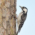
A Red-cockaded woodpecker, an endangered species, in a forest at the Cook’s Branch Conservancy.
‘It’s a false sense of security if people think it doesn’t matter that one species is disappearing. To me, that tells me the whole system is in trouble” – Sarah Scott Mitchell, granddaughter of George Mitchell
The Cook’s Branch Conservancy is located on 5,600 acres in Montgomery County. The land was purchased by Texas oil & gas billionaire George Mitchell in 1964.
“We’re now getting close to the condition the settlers found it in. We’re restoring grasses and doing controlled burns.” -Sheridan Mitchell Lorenz, daughter of George Mitchell
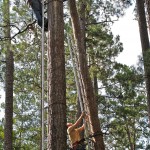
Naturalists improve breeding of the woodpecker by climbing old pines to build nests and remove predators like squirrels
Watching woodpecker return to feed hatchlings
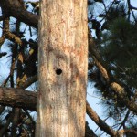
Woodpecker nest in old-growth pine
Woodpecker hatchling
“I can hear the difference. You can hear so many more song birds that I didn’t hear before. We’ve actually doubled our population of (woodpeckers) in 10 years” -Kathy Hutson (center), Conservancy Manager
Wildflowers in a restored meadow
Flock of Eastern Wild Turkeys on the conservancy, one of many species that benefited from the restoration.
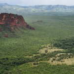
View of the Pantanal from the Cidade de Pedra viewpoint in the Chapada dos Guimaraes national park, Mato Grosso state, western Brazil on January 30, 2011.
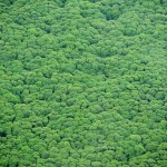
In this photograph taken on October 16, 2010 during an aerial survey mission by Greenpeace over Sumatra island shows a rainforest canopy of Sungai Sembilang National Park.
PlanetSolar achieves the first around the world with only solar energy, on May 4, 2012 in Monaco. The biggest solar boat ever built progressed through Atlantic Sea, Panama canal, Pacific Ocean and is back to Mediterranean Sea through Suez Canal.
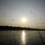
Picture taken on December 2, 2010 shows a flock of Great Cromonent birds flying over to Rapati River in Chitwan National Park, some 200 km southwest of Kathmandu.
A great white cloud reflected on a pond at the hotel Princeville Resort in Kauai (Hawaii).
The Dyes Slaughterhouse, part of the historic Dyes Store Butchery complex just outside of Kaukapakapa, New Zealand, today, Wednesday 19 May 2004.
A cameraman films the sea 21 November 2002 at the oil-covered Fuera beach in cape Finisterre, northwestern Spain.
What’s a carbon sink? It’s a process where the earth soaks up atmospheric carbon, which there is more and more of in the world. Those “sinks” take the form of forests and oceans, and a new study we reported on last week says that, contrary to previous research, the earth’s ability to soak up carbon has “increased roughly in line with rising emissions.” So herewith is a slideshow of some of those carbon sinks that are helping to eat up some of the carbon in the atmosphere.
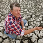
Texas is now at the same reservoir capacity levels it was during the drought of record in the 1950s.
While the recent drought was no honeymoon, the drought of record in the 1950s stands as a stark reminder of what could come to pass, said Todd Votteler, the Executive Manager of Science, Intergovernmental Relations, and Policy at the Guadalupe-Blanco River Authority. (You can read his presentation here.). Unlike the experience of the past year, the drought of record was the culmination of six to nine very dry years, he said. Emerging from the 1950s, authorities went to great lengths to increase the state’s surface water resources.
Unfortunately, this resource cushion has been all but depleted by the most recent drought experience and a growing population, Votteler said, leaving Texas at the same reservoir storage capacity per capita of 1953, the year that marked the beginning of the drought of record.
The Australian drought forced the country to make some tough decisions. Will Texas follow suit?
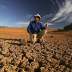
Stockman Gordon Litchfield from Wilpoorinna sheep and cattle station surveys the bottom of a dry dam on his property on June 7, 2005 in Leigh Creek, Australia.
Stockman Gordon Litchfield from Wilpoorinna sheep and cattle station holds a handful of bull dust on his property June 7, 2005 in Leigh Creek, Australia.
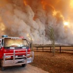
A Country Fire Authority (CFA) staff monitor a giant fire raging in the Bunyip State Park near Labertouche, some 125 kilometres west of Melbourne, on February 7, 2009. More than 40 blazes raged across two states as a once-in-a-century heatwave pushed the mercury as high as 46 degrees Celsius (115 Fahrenheit) with fire bans in place across much of the south-east, with conditions said to be the worst since the Ash Wednesday wildfires of 1983, which killed 75 people and razed 2,500 homes.
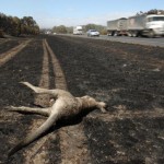
A dead kangaroo lies beside a burnt-out section of the Hume Highway near Seymour, some 100 kilometres north of Melbourne on February 9, 2009 as raging Australian wildfires left at least 131 people dead amid a landscape of charred homes, bodies and devastated communities. The wildfires have become the deadliest in Australia’s history, destroying entire towns and wiping out families and amid the heartache there was also anger as police revealed they suspected some of the fires were started by arsonists, whom Prime Minister Kevin Rudd accused of “mass murder.”
Farmer Marshall Rodda inspects an empty dam, leaving him with fields of stunted wheat stalks, normally thigh high, and which have only managed only a few inches growth in the parched earth of the Australian wheat belt in the fall of 2006.
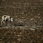
An emaciated sheep standing in a field June 13, 2005 near Port Augusta, Australia.
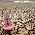
This photo taken 16 November, 2006 shows a warning sign for boats sitting on the bottom of the empty Green Hill Lake outside the small rural town of Ararat, some 170 kms west of Melbourne.
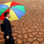
A man shelters from the rain under his umbrella as he passes a giant mural showing the drought-affected Australian outback which is blocking public view of a fountain, turned off to conserve water in Melbourne’s CBD, 18 May 2007.
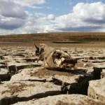
The remains of a fish lies on cracked ground at Wivenhoe Dam on April 10, 2007 in Queensland, Australia.
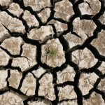
Cracked earth is seen at Wivenhoe Dam on April 10, 2007 in Brisbane, Australia.
An outdoor tap has cobwebs from lack of use May 11, 2005 in Goulburn, Australia.
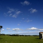
One question that comes up when looking at the Texas drought is, are there any examples of other droughts the state could look to? Texas isn’t alone dealing with the issues of water and drought, and one of the most recent examples of a large population dealing with drought comes from Australia. (You can see a slideshow of the Australian drought above.)
“Australia is the biggest drama that has recently played out in the world of water,” said Ralph Eberts, the Executive Vice President of Black & Veatch Water, at the Texas Water Summit at the University of Texas Monday. Australia is just now emerging from a severe decade-long drought. At the peak South East Queensland hung on with less than fifteen percent of its water supplies remaining. Aussie wildlife and agriculture took a considerable blow. And failed rice and grain crops threatened to unhinge the global food supply.
A parallel can be drawn between Australia’s drought experience and that of Texas. Australia, like Texas, was caught in a bind with no warning. The drought experience across Australia varied considerably, with different regions undergoing various levels of stress. Texas has witnessed this variability with West Texas drawing the shorter straw.
But the duration of the Australian drought led to markedly different results. Continue Reading →
Photo by Jillian Schantz-Patrick/StateImpact Texas / StateImpact Texas
Janna George of Fertile Ground Organic Gardens takes the grass lawn out of a backyard where hardier native species will be planted.
Landscape worker Janna George sweats in the midday sun as she thrusts her shovel into the ground. She’s trying to get up all the grass in the backyard of a South Austin home. As anyone who’s dug into the Central Texas ground and come out with a rock-dented shovel knows, there’s little dirt to dig into. So for the needs of her job, she says, she has to salvage as much precious soil as possible.
Why save the dirt but take away the grass? It’s because the company she works for, Fertile Ground Organic Gardens, designs landscapes to be more compatible with the Texas climate. They follow an ethic of conservation, viewing grass lawns as a unnecessarily thirsty option for our semiarid climate.
Consider the findings of one Texas survey: about 2/3 of residents’ water use in the summer goes to watering their yards. Is the desire to have a nice yard in opposition to conserving our volatile water sources? For co-owner of Fertile Ground, Alexa Villalobos, achieving the two is not only possible; it’s ideal. Continue Reading →
David Maidment says new data tools can help us better prepare for drought
Tracking the changes in water availability across the state using a variety of tools is an integral component of predicting and responding to drought. That’s what David R. Maidment of the Center of Research in Water Resources at UT had to say at the Texas Water Summit held Monday. As a member of the innovative Drought Technology Steering Committee at UT, Maidment presented a set of data that showed the impact of the drought.
Let’s just say that the picture Maidment’s painted wasn’t comforting. “It’s possible to quantify a very important impact of the drought on our state – the loss of vegetation,” said Maidment. A satellite image of the state taken before the drought revealed a lush green landscape. Seconds later, the newest satellite image of Texas was revealed – bone dry, yellowed, accented with the thin, wispy trails of remaining vegetation.
Researchers have increasingly turned to satellite imaging to gain a better handle on the situation. GRACE satellites, which measure the alterations in the force of gravity relative to water volume fluctuations, have indicated that over 100 cubic kilometers of water statewide was lost due to the 2011 drought. This figure amounts to the disappearance of approximately seventy Lake Travis’. Shallow groundwater reserves faired no better – over nine cubic kilometers were lost. Continue Reading →
The community just outside of Austin has been living without water for ten years.
Earlier this week we posted a video and audio report from Andy Uhler of KUT News (one of the public radio stations in the StateImpact Texas project) about a small community ten miles outside of Austin that lives without running water, the coloniaof Las Lomitas. In the second and third part of the series, Uhler and fellow KUT-er Danny Guerra report on why they don’t have water, broken promises to them about supplying it, and how the community is now banding together to secure it.
Guerra writes:
“When families moved into the Las Lomitas subdivision back in 2002, they had no idea they’d live without running water for 10 years.
“I’ve seen houses get built two miles down the road, they have everything,” said Las Lomitas resident Victor Soto. “Here we are, we’ve been here a lot longer than that and we still can’t water. I don’t know, I didn’t think it would be such a big deal, but it is.”
Las Lomitas started out as 150 acres of unincorporated land just north of Creedmoor. The land developer, Hank Peavler, split the land into 10-acre parcels and put them up for sale. But the law didn’t require him to run water lines into the neighborhood.”
And Uhler says that there’s hope that water could be coming to Las Lomitas soon. Continue Reading →
The Texas Commission on Environmental Quality is the state agency with final say in the new water management plan.
The Colorado River provides water to cities, towns, industry and agriculture from West Texas to the Gulf Coast. After 18 months of often bitter disagreement, representatives of those interests (referred to as stakeholders) reached a consensus last year for how that water should be managed from the Highland Lakes on down. After further tweaks, the Lower Colorado River Authority (LCRA) approved that Water Management Plan early this year.
Most stakeholders felt short-changed by the final Water Management Plan. But at the time of the LCRA‘s vote, many seemed relieved, at least, that a plan was finally complete.
Then, late last month, a letter arrived at the Texas Commission on Environmental Quality (TCEQ) that could throw everything back into question. That letter includes greivences from downstream rice farmers over how the plan was developed, and changes they would like to see.
Opponents are calling it a “rice farmer manifesto,” but Ed McCarthy, a lawyer representing Lower Colorado rice farmers, describes it differently. Continue Reading →
About StateImpact
StateImpact seeks to inform and engage local communities with broadcast and online news focused on how state government decisions affect your lives. Learn More »