Drought Monitor: A Slight Reversal
U.S. Drought Monitor
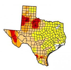
The state drought map released Thursday, May 31. The tan and red areas denote areas in drought.
After so much progress over the winter months, it’s a let down to see the drought map released today by the U.S. Drought Monitor showing a slight reversal in recent trends.
Despite an overall retreat of drought in Texas, the percentage of the state experiencing drought conditions actually increased by two percentage points since last week.
The Drought Monitor map released today reveals that 59.18% of the state is still in drought conditions, with parts of northwest Texas continuing to harbor islands of extreme and exceptional drought.
Recent weather for much of the state should allay some alarm, however. Wet weather passed through the Dallas-Fort Worth area yesterday and is in the forecast for much of the central and eastern parts of the state today. Still, some analysts say it’s anybody’s guess if wetter trends will continue.
“There’s just an equal chance of precipitation being above normal as there is being below normal,” Luigi Romolo with the Southern Regional Climate Center, told StateImpact Texas partner KUT News. “So unfortunately we don’t really have an answer of what’s going to come in the future. You could pretty much flip a coin and be just as right.”
Now, if only more of that rain could make it out to far west Texas and the Panhandle!