Mark Your Calendars For La Niña’s Farewell Party

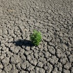
Photo by Jeff Heimsath/KUT News
A dock sits on the dried up bed of the Pedernales River in Travis County, Texas.
Stop me if you’ve heard this question before: When will the drought end?
It’s truly too soon to say, but there are some indicators that one of the main culprits, La Niña, is going to be leaving us soon.
What is La Niña? It’s a weather pattern where the surface temperatures are cooler in the Pacific, which creates drier, warmer weather in the southern U.S. (You may also know her counterpart, El Niño, which generally has the opposite effect.) La Niña sticks around for a year, sometimes longer, and tends to return once every few years. (The last La Niña was in 2007, but it was a much lighter one.)
The National Weather Service says today that a “majority of models predict La Niña to weaken through the rest of the Northern Hemisphere winter 2011-12, and then to dissipate during the spring 2012.” This jibes with previous forecasts.
But there’s a catch.
Related
Posts


The National Weather Service says that they “expect La Niña impacts to continue even as the episode weakens.” They say that during the next few months, it’s likely to be drier-than-average in the south. Victor Murphy is with the National Weather Service at their Southern Region Headquarters in Fort Worth, Texas. He says that it’s unfortunate that La Niña is taking her time, because the longer it takes her to leave, the less rain we get. “I would say for the springtime, which is our main time of year for getting rainfall across Texas, we’re more likely than not to see below normal precipitation,” he told Autumn Caviness of KUT News, StateImpact Texas’ reporting partner.
Fortunately, forecasts can be wrong. Despite predictions to the contrary, much of Texas has seen above-average rains in the first months of winter. Dallas/Fort Worth has become drought-free, and much of Harris County (and Houston) and all of El Paso are now in the lightest stage of drought, the “moderate” level. Austin and San Antonio have moved from the second level of drought, “severe,” from levels of “extreme” and “exceptional” before that. It’s fair to say that for the big population centers of Texas, drought conditions have improved greatly, but as you can see from the latest drought monitor released today, areas of extreme and exceptional drought remain:

Map by National Drought Monitor
The latest drought monitor shows improvements for the big cities in Texas
But what are the odds of La Niña coming back this fall and extending the drought even further? When La Niña showed up in the summer of 2010, she overstayed her welcome, returning the very next year for back-to-back La Niñas, which became a major factor in the drought. “In fact, it was the second strongest La Niña on record, and that was a strong contributor, perhaps a main contributor to the record-setting drought conditions we’ve had in Texas,” Murphy of the National Weather Service says.
So while this was a “double-dipping” La Niña, as Murphy says, what are the chances of a threepeat? History would tell us the odds are 50/50. In five out of the last ten two-year La Niñas, they were followed by a third year of the pattern. Texas state climatologist John Nielsen-Gammon told StateImpact Texas last month that there’s “no guarantee” that won’t happen this time, which would take the record single-year drought into even more extreme territory.
Here’s a video of La Niña in motion from the National Weather Service: