Texas Oil Spill Tracked With New High-tech Buoy
Texas A&M
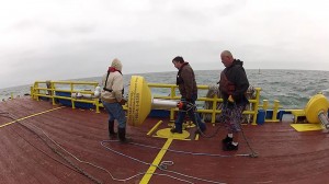
Near oil spill off Galveston Island, crew prepares to deploy rapid response tracking buoy built by Texas A&M
There are over 500 clean-up crew members working in boats and on beaches near where the oil spilled near Texas City on Galveston Bay.
But determining where some of the oil might still go is being done by experts who aren’t nearby. They’re over 2,000 miles away.
Doug Helton is in Seattle, Washington.
He’s in the war room the National Oceanic and Atmospheric Administration uses to help coordinate oil spill responses nationwide.
“The basic question is where’s the oil going to go, how’s it going to behave and what is it going to look like when it gets there, “ Helton told StateImpact Texas.
To predict that, NOAA uses data on the direction of the wind and currents and water temperatures.
“So far it’s tracking pretty closely to our predictions. We’re looking at the oil moving down along Galveston Island and towards the Freeport area,” said Helton.
The accuracy of those predictions relies on getting good data and how they get it in Texas could be making a big difference. The state uses what’s called TABS: Texas Automated Buoy System. TABS was developed by Texas A&M.
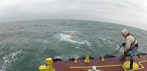
Texas A&M
A&M's buoy hits the water and begins sending back data on wind, currents, and waves
“It gives you real time information, allows you to direct your resources to where you think the oil is actually going to go,” said John Walpert at Texas A&M’s Geochemical and Environmental Research Group.
Starting almost 20 years ago, the group developed and has now launched nine buoys that are anchored along the Texas coast. The buoys send out real-time readings on wind speed and direction, water currents and weather conditions and how high the waves are. Some of the buoys even have radar that looks at conditions all the way down to the sea floor. Getting that data in real-time is critical to predicting where an oil slick may head, especially if a front moves in that causes quick shifts in wind direction.
Over the years, the buoys have helped track over 50 spills, big and small. But the buoy system isn’t perfect. Since there are only nine, they could be many miles from the actual spill location. So a few years ago, A&M began work on buoys that could be quickly deployed right at or near a spill site.
“We have something called a TABS responder buoy which is a quick response buoy which we designed and built just for an emergency such as this,” said Walpert.
This Monday, for the first time in an actual spill, A&M deployed one of the new, quick response buoys 12 miles off the western edge of Galveston Island in the path where the oil was headed. And so far, researchers say the new buoy is working fine.
The Texas Automated Buoy System was one result of the federal Oil Pollution Act of 1990. It called for more to be done to mitigate spills. The Texas legislature responded by imposing a penny-a-barrel tax on oil that is shipped through Texas ports, a fee that now provides millions of dollars for spill prevention and monitoring programs.
Texas officials say the buoy system is the most advanced in the country and Doug Helton with the federal spill response office said it is impressive.
“This system is really strong.”
And it may reduce the damage this latest spill will do to the Texas coast.