Harold and Nell Myers live in Lakeside Beach. He used to manage the community’s water system before it was sold to LCRA.
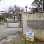
Spicewood Beach was placed under stage 4 water restrictions on Tuesday, meaning residents can only use water for cooking, cleaning and drinking.
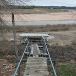
A beached boat dock on upper Lake Travis near Spicewood Beach sits dozens of feet from the water’s edge.
Clayton “Buddy” Howell, a Navy Veteran shares a modest home with his daughter in Spicewood Beach.
Boat docks that once floated on Lake Travis now sit on dry ground in Spicewood Beach.
Joe Barbera, the current president of the Spicewood Beach POA, sits in the community recreation center.
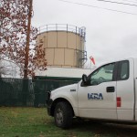
LCRA trucks parked outside a water pumping station in Spicewood Beach, where workers took measurements for the river authority engineers.
The Lakeside Beach community, along with Spicewood Beach, was put under stage 4 water restrictions Tuesday.
Ryan Rowney, LCRA manager of water operations, sits in his office near Red Bud Isle.
Andy Uhler and David Barer of KUT News contributed reporting to this article.
(Update: On Monday, January 30, the wells in Spicewood Beach began to fail, and water was trucked in. It was the first time during the current drought that a Texas town has run out of water. Read our latest reporting on the story here.)
The drought has come close to drying up several small Texas towns. Without exception they’ve all been spared, whether through rain, new water pipelines, or a mix of the two. But for the first time since the drought began, within a few days, one community’s well is expected to run dry.
Spicewood Beach sits on a peninsula along the northern reaches of Lake Travis. Inflows into the lakes that provide for the region are at a historic low, while water demand is at an all-time high. The two main water sources for Central Texas, Lakes Buchanan and Travis, are currently only at a combined 37 percent of their full capacity.
There are 500 water meters in the Spicewood Beach area, serving an estimated 1,100 people. Water is drawn from wells managed by the Lower Colorado River Authority.
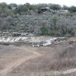
The irony of running out of water right next to a lake isn’t lost on locals like Joe Barbera, who is president of the Spicewood Beach Property Owner’s Association. “If you go down there, it’s nothing but sand,” he says. “If you actually walk down there, it’s unbelievable how far you have to go down to the creek bed just to see water.”
How Did This Happen?
Around here he’s known simply as “Buddy.” But his given name is Clayton Howell, an 85 year-old retired Navy vet who lives in a single-story home next to a golf course. Until about six months ago, you’d find him playing nine holes a day there. Now he’s more or less confined to his La-Z-Boy with a bad back problem. Over a late breakfast, he tells the story of how the local water wells came to be the property of the LCRA, and why they’re beginning to run dry. Continue Reading →
Which counties in Texas would be affected by the Keystone XL pipeline? Here’s a map from the State Department that outlines (in purple) the approved route of the Keystone XL pipeline from Cushing, Oklahoma to refineries in Texas: Continue Reading →
The Environmental Protection Agency has released a new interactive map today that allows you to explore greenhouse gas emissions throughout the country for 2010. Here’s a snapshot of Texas that links to the map:
Clusters of Greenhouse Gas Emitters in Texas (Map by EPA)
The largest emitter of greenhouse gases in the state for that year? The Luminant Martin Lake power plant, which mostly burns lignite. It released 18.7 million metric tons of greenhouse gases into the atmosphere last year and is the fourth largest emitter of greenhouse gases in the country.
Texas has 673 facilities reporting greenhouse gas emissions to the EPA, more than any other state. (California, in second, has 456.)Continue Reading →
New year-end data and maps from the government show what a year 2011 was for heat and drought in Texas. Records were broken across the state, as extreme weather reached levels never seen before.
First, Texas was truly a red state last year, winning the distinction of being the driest state in the nation. States in the northeast, however, had their wettest years ever:
Map by NOAA
Some more detailed data gives a sense of how intense the drought was for all of Texas and portions of surrounding states: Continue Reading →
Reader CT was one of the first to ask “How about leaving that oil in the ground and seeking renewable energy sources?” Reader Dale096 agreed, saying “The extraction of this oil uses and pollutes unfathomable amounts of water and destroys vast tracts of Boreal forests. Invest in alternatives, leave fossil fuels in the history books.” Continue Reading →
A map of the internet response to the Ohio earthquake, with its epicenter
What happened with the earthquake in Ohio over the weekend, and how is it linked to fracking? Here’s what we know:
The earthquake measured 4.0, the largest in Ohio this year.
The New York Times is reporting that Ohio officials say the earthquake wasn’t caused by fracking, but rather by injection wells disposing of used fracking fluid. These wells are used to send the wastewater from fracking (a mix of water, sand and chemicals) deep underground for disposal.
The Times is also reporting that officials in Ohio say dispoal operations will “remain halted in the Youngstown area until scientists could analyze data from the most recent of a string of earthquakes there.”
This is the eleventh earthquake in the Youngstown area this year, and the most intense one. The earthquakes have all taken place near an injection well that goes 9,200 feet deep, according to the Times, and “as been used for the disposal of millions of gallons of brine and other waste liquids produced at natural-gas wells.” Continue Reading →
The Canadian company behind the proposed Keystone XL pipeline, which would bring crude from the country’s oil sands to refineries in Texas, got a little gift to end out the year from the Nebraska government this week: a map of where not to put the pipeline.
The pipeline ran into a snag earlier this year after Nebraska lawmakers opposed the route planned by the company, TransCanada, which would have gone through an environmentally-sensitive region known as the Nebraska Sandhills. The Sandhills are home to a giant freshwater aquifer that is used for water supply. (The pipeline also met with opposition from several environmental groups, who said it would increase reliance on fossil fuels.)
The ground is so thin in some parts of the area that groundwater on occasion rises to the surface. Water there is used primarily for irrigation, but it’s also used for drinking water by some 2 million people, according to the US Geological Survey.
Nebraska lawmakers passed legislation in November saying an alternative route that avoids the Sandhills must be found in order for the project to go forward. With the release of this map, it seems Nebraska wants to give the pipeline company that opportunity. Continue Reading →
A map shows the 0.01 percent of Texas no longer in drought.
Christmas came a little early for a small slice of Texas this year. We can now say that part of Texas is no longer in drought. A small part, to be sure, only 0.01 percent, but it’s happy news nonetheless.
According to new data from the National Drought Mitigation Center at the University of Nebraska (with a grateful hat tip to Kate Galbraith of the Texas Tribune), a sliver of Texas along the Texas-Oklahoma border is officially drought-free. Just east of Paris, Texas, 3.7 percent of Red River County is no longer in drought, representing 0.01 percent of the entire state. Continue Reading →
The City of San Antonio cut the ribbon on six electric vehicle charging stations today. There are about 50 electric vehicles currently in use in the city,according to the San Antonio Express-News. The city covered the $10,000 total cost for the project through a Department of Energy grant. It takes about four hours to recharge a plug-in hybrid like the Chevy Volt.
There are already two solar charging stations at the airport, the Express reports, bringing the number of city charging stations to eight. The stations are free to use.
A drought is a strange type of disaster. While hurricanes, tornadoes and floods do their damage quickly and dramatically, drought is like a slow death, a drying out of life and land. A house can be rebuilt after a flood recedes, but with a drought all you can do is wait for rain. And wait.
StateImpact seeks to inform and engage local communities with broadcast and online news focused on how state government decisions affect your lives. Learn More »