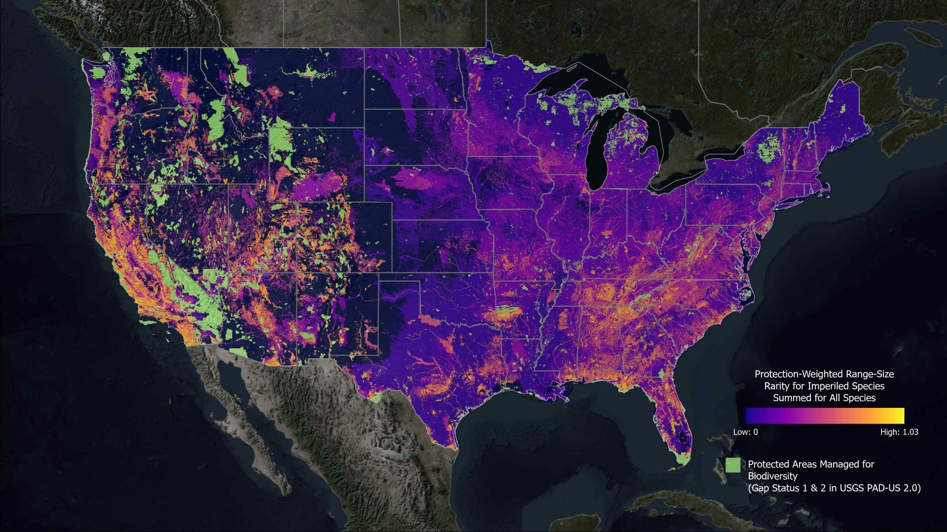
This map displays richness of at-risk species outside of existing protected areas using modeled distributions for 2,216 of the most imperiled plants and animals in the United States. Brighter colors indicate where land and water protection will most benefit the least protected yet most threatened biodiversity in our nation.
Courtesy NatureServe
New study takes close look at where to protect at-risk species
I report on energy and the environment for StateImpact Pennsylvania at WITF.
My work focuses on responses and solutions to climate change in the state legislature and communities around the state. I trace my interest in these issues back to my time as a Girl Scout and this episode of Rocko’s Modern Life.
I look forward to winter just for the chance to ski a few times each season. I try to keep myself from doom-scrolling on my phone by keeping my hands busy knitting and learning to play the piano.
I grew up in Cambria County, Pa. and graduated from Temple University. I started at WITF just after Christmas in 2014.
Courtesy NatureServe
This map displays richness of at-risk species outside of existing protected areas using modeled distributions for 2,216 of the most imperiled plants and animals in the United States. Brighter colors indicate where land and water protection will most benefit the least protected yet most threatened biodiversity in our nation.
Authors of a recent study that zooms in on areas across the country important for protecting threatened species hope the work will help with conservation efforts.
The study, led by the conservation data organization NatureServe, used new modeling techniques to look at habitats for more than 2,200 at-risk species. It found the ranges of most threatened species across the country are not contained in protected areas.
Chris Tracey, a Conservation Planning Manager with the Pennsylvania Natural Heritage Program who worked on the study, said they had access to 50 years of data from state programs.
“We have this incredible data set of rare species locations, and we’re able to take that and combine that with environmental predictors–things like elevation, our forest cover, or different types of soil or geology–combine that with a computer model and then make predictions on where suitable habitat for the species may occur,” Tracey said.
Pennsylvania has relatively few areas of high importance for threatened species that are not already protected.
Rare species in Pennsylvania include a flower, the serpentine aster, and the frosted elfin butterfly. Both are found in ecosystems called the Serpentine Barrens in southeastern Pennsylvania.
Also included are six types of federally endangered freshwater mussels found in the Allegheny and Delaware rivers.
Tracey said mussels may face more challenges from global warming. Pennsylvania is expected to become warmer and wetter as the climate changes.
“We’re seeing changes in summer precipitation,” Tracey said. “We may have more, higher frequent flows in the summer, which may have a negative impact.”
Mussels, which act as a water filter for their ecosystems, have been threatened by pollution and development such as dams.
The study used the U.S. Geological Survey’s Protected Areas Database of the United States to classify areas. To be protected, land must be primarily managed for biodiversity.
Tracey said the study did not consider any land with multiple uses–such as timbering–to be “protected” for biodiversity. But that land is still suitable for conservation. He said many species can tolerate some disturbances.
“We really hope that this map is used by everyone and inspires them to go and help conserve these important biodiversity resources,” Tracey said.
Melissa Kreye, an assistant professor of ecosystem science and management at Penn State, who was not involved in the study, said the paper is a good resource.
“Mapping the distribution of threatened species is one way of understanding where to place incentives for habitat on the landscape so that the species is best supported. Support may include protecting large sections of habitat, or protecting habitat corridors so the species can safely move through urbanizing areas or relocate to new regions due to changes in climate,” Kreye said.
Andrew Wilson, an associate professor of environmental studies at Gettysburg College and also not involved in the study, called the analysis in the paper exceptional.
He said it’s not surprising that the commonwealth does not have many areas of unprotected land that are considered important, because the state has a dense network of protected areas, especially state game lands.
Wilson added the maps put state conservation priorities within a national context.
“For example, if we examine potentially imperiled species and habitats in Pennsylvania, we are rightly concerned about high elevation and northern species that we may lose from the state in coming decades due to climate change,” Wilson said in an email. “However, many of these species are abundant further north, so their loss from PA may be insignificant in the range-wide context. But, that’s not to say their loss from PA doesn’t matter to residents of The Commonwealth.”
StateImpact Pennsylvania is a collaboration among WITF, WHYY, and the Allegheny Front. Reporters Reid Frazier, Rachel McDevitt and Susan Phillips cover the commonwealth’s energy economy. Read their reports on this site, and hear them on public radio stations across Pennsylvania.
Climate Solutions, a collaboration of news organizations, educational institutions and a theater company, uses engagement, education and storytelling to help central Pennsylvanians toward climate change literacy, resilience and adaptation. Our work will amplify how people are finding solutions to the challenges presented by a warming world.