Mapping Nuclear Fallout One Year After Fukushima
-
Susan Phillips

Stan Honda / Getty Images
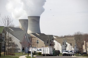
Cooling towers from the Limerick Generating Station, a nuclear power plant in Pottstown, Pennsylvania, are seen from a nearby neighborhood.
The Natural Resources Defense Council has a new mapping tool that charts potential deadly nuclear fallout at U.S. plants in the wake of an accident. The NRDC released the map a week before the first anniversary of the Fukushima nuclear disaster, which was touched off by an earthquake and tsunami that damaged the Japanese plant. Matthew McKinzie, NRDC’s senior scientist writes in his blog that U.S. plants are at risk of a similar meltdown.
“Unfortunately, the chance of a severe accident at a U.S. nuclear power plant is a very real threat – and it wouldn’t take an earthquake and tsunami to trigger it. The fundamental cause of the disaster in Japan was that the reactors lost both primary and back-up power sources. More common weather patterns – like flooding, tornadoes and hurricanes – could have the same impact and in fact five nuclear power plants in the U.S. underwent emergency shutdowns due to such extreme weather events in 2011 as flagged in NRDC’s map.”
The NRDC plotted the fallout using weather patterns recorded during March, 2011. Five U.S. nuclear reactors lost power in 2011. The map plots potential radiation plumes from Pennsylvania’s four nuclear power plants. According to the NRDC, the fallout from Delaware’s Salem nuclear plant would also reach the state. After Fukushima, the Nuclear Regulatory Commission formed a task force, held public hearings, and gave congressional testimony on proposed safety upgrades at nuclear plants. NRDC’s Jordan Weaver details the actions taken, and not taken, by the industry and the NRC since Fukushima.
For an insider’s look at how workers at the plant responded, and the resulting impact of the meltdown, check out Frontline’s piece on the Fukushima nuclear disaster.


