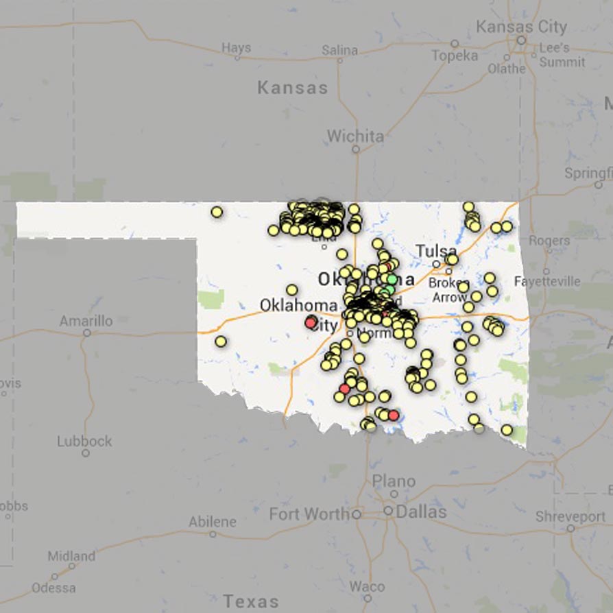
Click here for StateImpact's interactive map of Oklahoma's 2009-2013 earthquake "swarm."
Joe Wertz / StateImpact Oklahoma

Click here for StateImpact's interactive map of Oklahoma's 2009-2013 earthquake "swarm."
Joe Wertz / StateImpact Oklahoma
More than a dozen small earthquakes shook central Oklahoma over the weekend, including several temblors that were 3.0-magnitude or higher, which people can generally feel. Did you feel the shaking? Find details on the earthquake near you. » UPDATED: 02/17/2014
The tremors are the latest in a swarm of quakes the U.S. Geological Survey says may be linked to waste fluid disposal wells used by the oil and gas industry. The swarm began in 2009, and has included more than 200 magnitude 3.0 or greater temblors. The “unusual” earthquakes don’t appear to be natural, and USGS seismologist Bill Leith has issued a warning of increased quakes throughout central Oklahoma.
StateImpact has mapped the earthquakes from 2009 to present, using data from the Oklahoma Geological Survey. Click around the map to see details on the time, location and magnitude of earthquakes near you.
Independent geophysicists have also linked earthquakes in Oklahoma — and other states — to disposal wells, which are used to store toxic drilling fluid deep underground, where it won’t contaminate water supplies. The swarm includes Oklahoma’s largest earthquake, a 5.7-magnitude temblor that shook the ground near Prague in November 2011, which some geophysicists say could be the largest linked to drilling activity.
StateImpact’s map shows earthquakes with a detectable magnitude recorded in Oklahoma from Jan. 1, 2009 to Feb. 17, 2014, and was built with data compiled by the Oklahoma Geological Survey. The red dots represent 3.0-magnitude or greater quakes, which people nearby are likely to have felt.