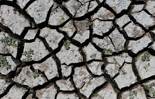
Dried up mud from the lake bottom at Lake Arrowhead State Park near Wichita Falls, Texas, September 2013.
Even if Rains Return, Climate Change Still Puts Texas Water Supplies at Risk
After years of drought, the city of Wichita Falls in North Texas is going to Stage 4 water restrictions this week, which bans all outdoor watering: No car washes. No more city water for golf courses. And no watering your lawn, of course. It’s the first time the city has moved to this stage, declaring a “drought disaster.”
While a lack of rainfall is certainly to blame for the sorry state of reservoirs in the region, it isn’t the only culprit. Evaporation has also played a big part in making the drought so destructive.
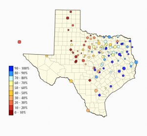
Map by Texas Water Development Board
Reservoir levels across the Western half of Texas remain dangerously low.
A typical year in Wichita Falls will see around 28 days with temperatures of a hundred degrees or higher. In 2011, they had 100 days over 100 degrees.
“Think about that for a minute,” Rusell Schreiber, Public Works Director, said while announcing the new restrictions this week. “That’s over three months of temperatures over a hundred degrees. One-fourth of the entire year.”
All that heat leads to more evaporation in the large, shallow reservoirs of North and West Texas. And it’s not limited to that region. Last year, the Highland Lakes, reservoirs for the city of Austin, lost more water to evaporation than the entire city used from them over the whole year. Continue Reading →
MAP BY MICHAEL MARKS. A map of Texas Counties that participate in the National Flood Insurance Program. Counties in gray have insurance, counties in yellow have never had insurance, and counties in red do not currently have insurance, but have at some point. NOTE: Cities and towns may participate in the program even if their county does not.
The floods that killed five people and damaged over 1,000 homes in Austin on Halloween morning threw the danger of floods into stark relief. But when it comes to guarding against risky development in flood-prone regions, there’s little consistency from one Texas community to the next, with some areas still lacking any regulation.
The reason goes back to the way the state and local communities choose to adopt, or not adopt, the National Flood Insurance Program.
Update: The Texas Parks and Wildlife approved new rules today to prevent the spread of Zebra Mussels that will have an impact on boaters and fishers in 17 North Texas counties. “Anglers and boaters leaving or approaching public water will be required to take all reasonable steps to drain all water from their vessel, including live wells, bilges, motors, and any other receptacles or water intake systems that resulted from contact with public water,” the department says. ”
As a result of this rule, live fish could not be transported in water that comes from the water body where they were caught, which could impact off-site tournament weigh-ins. Personally caught live bait could be used only in the water where it was caught.” The new rules apply to any public waters in the following counties: Collin, Cooke, Dallas, Denton, Fannin, Grayson, Hood, Jack, Kaufman, Montague, Palo Pinto, Parker, Rockwall, Stephens, Tarrant, Wise, and Young counties. The rules will go into effect either December 10, 2013.
Original story, September 12, 2013:
If you boat or fish around Dallas-Fort Worth, your lake trips next summer could take a little extra time: new rules that could help prevent the spread of invasive zebra mussels were released for public comment this week, and if approved, boaters in 17 counties in Northeast Texas would be affected.
Zebra mussels have spread rapidly in the region after originally being discovered at Lake Texoma in 2009. Since then, they’ve been found in other lakes, like Lake Bridgeport joins Lake Texoma, Lake Ray Roberts, and Lewisville Lake. (You can what lakes have zebra mussels in the map above by Michael Marks.) Continue Reading →
How Texas counties voted on Prop 6. Counties in Blue passed the measure; Counties in Red voted against it. Map by Matt Wilson/StateImpact.
There wasn’t much nail-biting on either side of the Proposition 6 debate as people watched the votes come in on Tuesday. The measure, which will move $2 billion dollars from the state’s Rainy Day Fund to start a fund for water projects, won approval from over 73 percent of the state.
But as poll watchers began digging into the turnout, competing versions of what those numbers mean for the future of water in Texas began to take shape.
Speaker of the House Joe Straus, R-San Antonio, led the Water Texas PAC, which spent nearly two million dollars to promote the measure, pointed to the broad base of support to call the victory a triumph for bi-partisanship and coalition building.
“Small businesses, manufacturing, the energy industry, farmers and ranchers all came together very strongly,” said Straus at his PAC’s election night party.
Opponents of the measure say the way people voted points to a looming confrontation between water-rich rural areas and thirsty urban consumers. Continue Reading →
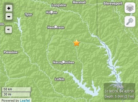
Location of the earthquake that occurred Wednesday morning.
Another minor earthquake close to the Barnett Shale rumbled through north Texas this week.
The quake occurred at around 8:30 Wednesday morning about one mile west of Ovilla, Texas. Ovilla partially lies in both Dallas and Ellis counties, about 20 miles south of Dallas.
The Ovilla earthquake’s magnitude registered as a 2.4 on the Richter scale. Although the United States Geological Survey (USGS) says that an earthquake with a magnitude of less than 3.5 isn’t typically noticeable, at least three people reported feeling the quake to the USGS web site.
Ovilla Fire Department Captain Brandon Kennedy said that he didn’t feel the earthquake, nor did he receive any calls about it. According to Kennedy, it was the first earthquake he’d even heard of in his hometown.
“I’ve never known of [an earthquake] since I’ve lived in Ovilla,” Kennedy said.
Texas has more dams than any other state in the country. This is a map of Texas dams from the USACE.
This is part three of a series looking at the infrastructure of dams in Texas, and what can be done to improve it. You can find part one here, and part two here.
In 1978 a massive storm hit the West Texas town of Albany. It dumped 23 inches of rain in just eight hours. Waters caused 9 deaths, flooded hundreds of homes, and broke through a local dam. Troy Henderson, who now works on the Brownwood Texas Lake Patrol, says since then he’s followed a simple rule.
“If I were to build a home somewhere, I’d make sure that if it was downstream from a lake that their dam is property maintained,” he told StateImpact Texas, “and the reason I say that is, I lived in Albany in 1978.”
The Federal Government echoes that advice. In the FEMA booklet “Living with Dams,” the agency urges people to “ask questions” about the condition and hazard rating of dams near their homes.
But here in Texas, no one needs to answer those questions.
A photo of a rusted out pipe taken during a TCEQ inspection of a dam. This picture is now used in dam safety workshops presented by TCEQ.
This is part two of a series devoted to looking at the infrastructure of dams in Texas, and what can be done to improve it. You can find part one hereand part threehere.
In 2008, the Texas State Auditor’s office released the kind of report that keeps public officials awake at night. It found that state regulators were not ensuring the proper maintenance of thousands of dams in Texas. The audit found that state inspectors had never visited hundreds of dams that could cause loss of life if they failed.
The Dam Safety Program with the Texas Commission on Environmental Quality is in charge of inspecting the state’s dams. Warren Samuelson, the program’s manager, says that his department has added staff and made progress since that audit was issued.
“At the end of 2011 we had all of them… except a handful that we couldn’t get into. We were able to look at all of these high and significant hazard dams,” Samuelson told StateImpact Texas.
A third earthquake shook Timpson,Texas early this morning. It measured a 2.4 on the Richter Scale and comes on the heels of two stronger quakes that hit on Labor Day. At least one of those prompted reports of damage.
If you visit this site often, chances are you’ve read about Timpson. It’s an East Texas community home to just over 1,100 people that seems to get more than its fair share of earthquakes.
Up until the recent spate of quakes, Timpson had never felt an earthquake before, at least not since the USGS started keeping records. That might be related to something else that Timpson has in abundance: injection wells for storing waste water produced by hydraulic fracturing, or fracking.
Science has proven the link between injection wells and seismic activity (which is the same thing as earthquakes). And researchers are studying that link in Timpson.
Texas is the nation’s leader in oil, natural gas, and wind production. But what parts of the state are doing the heavy lifting when it comes to energy?
Last week, StateImpact Texas used data from the Railroad Commission of Texas and thewindpower.net to answer that question. We created maps that showed how much oil, natural gas, and wind energy each county produced between June 2012 and June 2013.
After digging even deeper into the data, we’ve come up with five key takeaways for what those maps mean, and why they’re important.
Pecos County is Texas’ All-Around Energy Leader
Out of Texas’ 254 counties, remote and arid Pecos County is the only one that ranks in the top 25 for oil, natural gas, and wind energy production. Few counties in the Trans-Pecos region are rich in fossil fuels, so Pecos County’s oil and natural gas operations (21st and 19th in the state, respectively) are unusual. Its wind production though is right in line with other West Texas counties — it clocks in as the state’s fifth-best.
Texas is oil country. It leads the nation in oil production, and would be one of the top oil-producing nations if it were its own country. This map illustrates those points by breaking down Texas’ oil production by county.
The data for the map comes from the Texas Railroad Commission’s data query feature. This particular data set shows how many barrels of oil each county produced between June 2012 and June 2013.
Not surprisingly, the most intense production came from the Eagle Ford Shale and Permian Basin regions. The most prolific county over the past year was Karnes County, which is about 60 miles southeast of San Antonio. Oil operations in Karnes County shipped out over 46 million barrels of oil last year. The only regions which did not produce much oil were the Hill Country and the extreme northeast part of the state.
About StateImpact
StateImpact seeks to inform and engage local communities with broadcast and online news focused on how state government decisions affect your lives. Learn More »