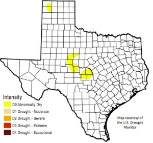
The latest drought report from the Texas Water Development Board has some good news. After more than five years, spring rains saturated the ground enough to finally end our long drought — our long soil moisture drought. But that doesn’t mean water shortages don’t still plague some parts of the state, and that water challenges wont stay with Texas into the foreseeable future.
“So we have hydrologic drought,” says Robert Mace with the Texas Water Development Board.
He says the ground is doing great, but parts of the state need much more rain to replenish their reservoirs.
“If you look at Lake Abilene, which is, believe it or not…3.4 percent full. And that was last full in 2011. Another example is Lake Meredith, up north of Amarillo, [which is] 15.6 percent full currently,” Mace says.
Mace is optimistic those and the rest of the state’s reservoirs can recover this winter, when El Niño conditions are expected to bring us more rain.
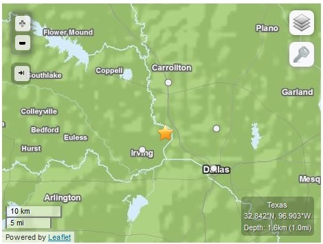
This map from the USGS shows the approximate location of a recent quake near Irving, Texas.
Updated 1/6/14 with more comment from Railroad Commission and information on Tuesday January 6th earthquake.
A team of seismologists headed to the North Texas town of Irving Monday. Like some other Texas towns, Irving has experienced scores of small earthquakes lately, 20 since last September, including a magnitude 3.5 quake that struck on January 6th. And the city is hoping to figure out what’s behind the shaking.
The upsurge in quakes started in Texas around the time the oil and gas boom took hold several years ago. Residents in many parts of the state blame the them on wastewater disposal wells, where fluid byproducts of oil and gas drilling are pumped deep into the ground. Scientists have shown how injecting fluid into the ground can cause earthquakes.
After a spate of quakes in the North Texas town of Azle, the Railroad Commission of Texas, the state’s oil and gas regulator, hired a seismologist, Dr. David Craig Pearson, and passed new regulations for disposal wells. The Commission says it is not investigating the Irving quakes.
“The Railroad Commission is not investigating seismic activity around Irving,” Ramona Nye, a spokesperson for the Commission wrote in an email to StateImpact Texas. “Specifically, there are no disposal wells in Dallas County, and there is only one natural gas well in the vicinity, and it is an inactive well.”
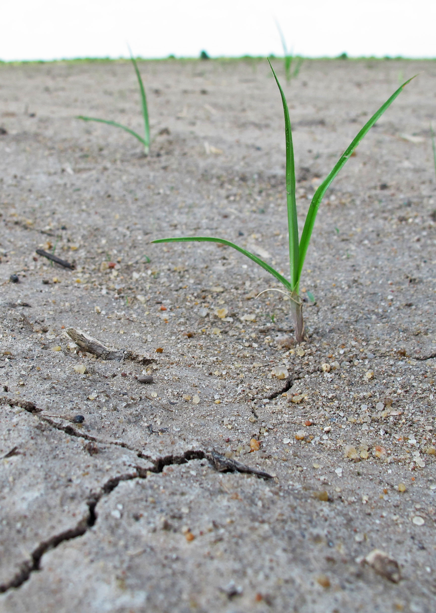
In the floodplain, several inches of fine silty mud sit atop thick, heavy clay. The clay is the finest dust eroded by the river, carried until this point then deposited as the river spreads out across the prairie. The silt is a thick rich mixture of sediment from upstream. The land in the floodplain naturally holds water very well.
In 2012, some farming districts on the Lower Colorado River were cut off from water for irrigation for the first time. Reservoirs were too low to flood tens of thousands of rice fields. Some asked, “Why would anyone be farming rice in Texas in the first place?”
The answer is long, and it begins with the fact that parts of Texas haven’t always been dry. For farmers like Ronald Gertson, who remembers driving a tractor through rice fields as a child, recent years have been hard to bear.
“It’s just unbelievable that it’s been so bad that we have had three unprecedented years in a row, and I recognize some experts say we could have a couple of decades like this. I hope and pray that’s not the case,” says Gertson, a rice farmer, chair of numerous water-related committees and, in recent years, unofficial spokesman for the Texas Rice Belt. “If that is the case then yeah, this whole prairie is going to change.”
“Texas’ air monitoring system is so flawed that the state knows almost nothing about the extent of the pollution in the Eagle Ford. Only five permanent air monitors are installed in the 20,000-square-mile region, and all are at the fringes of the shale play, far from the heavy drilling areas where emissions are highest.”
“Thousands of oil and gas facilities, including six of the nine production sites near the Buehrings’ house, are allowed to self-audit their emissions without reporting them to the state. The Texas Commission on Environmental Quality (TCEQ), which regulates most air emissions, doesn’t even know some of these facilities exist. An internal agency document acknowledges that the rule allowing this practice “[c]annot be proven to be protective.” Continue Reading →
A picture provided to StateImpact Texas from property rights activist Julia Trigg Crawford of what she said was work on the Keystone pipeline.
Before the oil started flowing in earnest through the southern part of the Keystone XL pipeline last week, land owner and property rights activist Julia Trigg Crawford noticed work crews unearthing parts of of the pipeline. When StateImpact called Crawford for a quote about the pipeline’s activation, she mentioned that activity.
“Track hoes, skids, water trucks, electrical trucks and construction crews showed up,” Crawford said. “They unearthed the pipeline, attached wires and sensors, wrapped it in something and then covered it up.”
Crawford added that TransCanada, the company that owns the pipeline, told her it had been installing temperature sensors. StateImpact Texas emailed TransCanada for confirmation, but did not hear back by the piece’s Wednesday morning deadline, a fact noted in the original article.
Wednesday evening TransCanada sent an email explaining the work.
Residents of the quake-stricken area called on state regulators to immediately suspend operations at the wells believed to be behind the tremors.
Dozens of residents and local officials from the towns of Azle, Reno and Springtown outside of Fort Worth bused down to Austin Tuesday to speak before state regulators about a swarm of recent earthquakes believed to be tied to the oil and gas industry. They had plenty of questions for the Railroad Commission, the state’s oil and gas regulator, but the commission had few answers.
While the quakes have been relatively small, not big enough to cause major damage, there’s been a lot of them: more than thirty over the last few months. They’ve caused cracks in homes, sinkholes and more than a few rude awakenings.
“The quakes started recently, and I didn’t think much about it until I was asleep at midnight,” testified Springtown resident Phil Doss. “It woke me up. I thought a 747 had landed on my roof. It was that bad.”
Springtown is one of several towns in Texas that saw a sudden onset of quakes over the last few years as a drilling boom expanded throughout the state. No earthquakes struck the Dallas-Fort Worth region before 2007, according to records from the United States Geological Survey. There have been more than a hundred since. Continue Reading →
View Earthquakes Near Azle, Texas in a larger map Map created by Andrew Weber for KUT News and StateImpact Texas. Orange circles represent earthquakes, wavy blue lines represent active wastewater disposal wells.
Another minor earthquake shook the North Texas community of Azle on Monday. It’s one of dozens to hit the region over the last few months that have residents on edge and complaining of property damage.
Many see a link between the quakes and increased oil and gas activity. But challenges confront scientists researching the quakes for the U.S. Geological Survey and Southern Methodist University. For one, they’ve needed to more accurately pinpoint the epicenters of the Azle quakes.
“The closest seismograph station used by the National Earthquake Information Center to locate the Azle earthquakes is over 60 miles to the south, the next closest is 125 miles to the West,” USGS Seismologist Williams Ellsworth explained in a letter to Azle Mayor Alan Brundrett in a December letter obtained by StateImpact Texas (embedded below).
In that same letter, Ellsworth explains how he has produced a more accurate map of the quakes, one that shows them clustered in a more concentrated location than previously thought.
“To date, it looks like the earthquakes are all in one very localized zone,” Ellsworth confirmed to StateImpact Texas over the phone.
After 20 earthquakes in a month, will state regulators respond?
State Oil and Gas Regulator Says No Changes Needed After Latest Earthquake Swarm
After twenty minor earthquakes in a month, residents in the small towns of Azle and Springtown outside of Fort Worth are understandably confused about why their once-stable region is now trembling on a near-daily basis.
Teachers in the Azle school district are taking a page from the California playbook and holding earthquake drills for students. Inspectors are making regular visits to the earthen Eagle Mountain Lake dam, as well as others in the area, checking for damage. (So far they’ve found none.) And locals like Rebecca Williams are constantly looking at their own homes for damage. So far she’s found cracks in her home, driveway and in a retaining wall in her backyard.
The quakes have been small, below the threshold that is known to cause significant damage. But they’ve unnerved residents like Williams, who moved out to Eagle Mountain Lake looking for some peace and quiet.
“You can actually see my house rocking from side to side,” Williams says. She was at home when the largest of the quakes (magnitude 3.6) struck on the evening of November 19th. “I tried to get up and run downstairs,” she says. “And for a moment, I couldn’t run, because the house was shaking so bad!”
A map of recent earthquakes (in red) and oil and gas wastewater disposal wells outside of Fort Worth. Active disposal wells are in green; inactive wells are in yellow. Map by Michael Marks/Terrence Henry
Ten Seventeen* earthquakes in just a month, the biggest a magnitude 3.6. That’s what small towns like Azle and Springtown Northwest of Fort Worth have had to deal with recently. (*More quakes have struck Azle since this story was originally published: on November 21, 23, 25, 26 and 29. The Nov. 25 quake measured 3.3.)
The region is also home to several disposal wells, which are used to store massive amounts of wastewater from oil and gas drilling. In other parts of the Barnett Shale drilling area disposal wells have been linked to similar series of quakes. You can see where the quakes have occurred recently around the town of Azle, as well as active and inactive disposal wells in the region, in the map above. The quakes are in Tarrant and Parker counties.
A map of reported Anthrax cases in Texas, by county. Map by Michael Marks
Texas is cattle country: there are nearly 13 million cows wandering through Texas, according to the United States Department of Agriculture. That’s over 14 percent of the country’s total cattle population.
And our bovine friends have some company: there are also approximately 1.3 million goats, nearly one million horses, and 3.6 million deer.
So if just one grazing animal died of a lethal and highly transmittable disease, there would be cause for concern that large numbers of animals could be at risk.
StateImpact seeks to inform and engage local communities with broadcast and online news focused on how state government decisions affect your lives. Learn More »

