Maps of the Texas Drought: The Beginning, Peak, and Today
The current drought in Texas, which broke single-year records, has shown dramatic abatement in recent months as rains surprised the state. It was supposed to be a drier-than-average winter, but thankfully forecasts can be wrong.
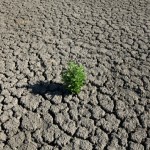
Maybe you’re curious to see how far Texas has to go before things get back to “normal?” Quite a way. These three maps from the National Drought Monitor show the progression (and, hopefully, regression) of the drought, from its beginning in October 2010, to its arguable peak in October of the following year, to the improved-but-far-from-out-of-the-woods condition we find ourselves in today:

Maps by National Drought Center
Read more at our topic page, Everything You Need to Know About the Texas Drought.